If you operate outdoors, you know the drill: SOTA has one map, POTA another, WWFF yet another. Spots are scattered, rules are everywhere. The idea came up during the Dobratschrunde — a regular on-air roundtable: Why is there no single map for all of this? After several QSOs and lots of feedback, xOTA Map was born.
What does it do?
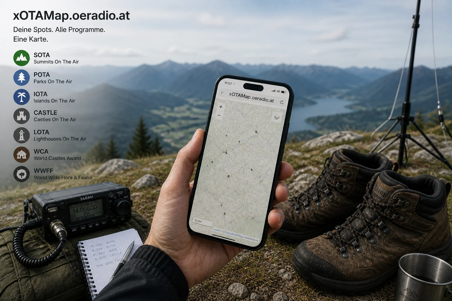
xOTA Map shows reference points from 34 outdoor programs on a single interactive map. 11 programs have dedicated map layers (SOTA, POTA, WWFF, GMA, IOTA, TOTA, WCA, WWBOTA, WLOTA, ILLW, ARLHS) that you can toggle on and off. Click any point for reference numbers, details, and links to the official database.
The Killer Feature: “What Counts Here?”
Right-click anywhere on the map (or long-press on mobile) to see every program that applies at that location, with distances to nearest reference points. Standing on a SOTA summit that is also in a WWFF area next to a COTA castle? xOTA Map shows you instantly. Perfect for multi-activations.
Live Spots
Real-time spots from 21 programs via the Spothole API. On the map and as a filterable table — by program, band, mode, and age. Updates every 60 seconds. See who is activating where, right now.
Browser Logbook
Need a quick log on the summit? xOTA Map has a simple QSO logbook right in the browser. No account, no cloud — everything stays on your device. Export as ADIF and upload to SOTA, POTA, GMA, or Wavelog. Your phone is enough.
Encyclopedia
All 34 programs explained in the built-in encyclopedia — in German, English, Italian, and Slovenian. Rules, activation requirements, awards, hunter/chaser info, official links. If you have been wondering what TOTA, HEMA, or BOTA actually are — you will find it here.
Key Programs
- SOTA — Mountain summits. The original, points by height.
- POTA — National parks. Fastest-growing program worldwide.
- WWFF — Nature reserves. 44 QSOs for a valid activation.
- GMA — Global Mountain Activity. Outdoor radio without compromise — mountains, castles, lighthouses and more.
- IOTA — Islands worldwide. Classic since 1964.
Works Offline
xOTA Map is a PWA — install it on your home screen and use it even with poor reception. Map data is cached locally.
Try it now
Free, runs in your browser, no installation:
Beta — Feedback Wanted!
The tool is in beta and actively being developed — your feedback decides what comes next. What is missing? What is annoying? Write to [email protected], drop a comment below, or join the oeradio.at WhatsApp group.
Open Source — Contributors Welcome!
xOTA Map is open source. The full code is on GitHub. Want to contribute — new features, bugfixes, additional program sources, or UI improvements? Pull requests, issues, and ideas are welcome. Stack: React, TypeScript, MapLibre GL, Tailwind CSS, Vite. Everything runs client-side, no backend needed.
73 de OE8YML